BMW was very early! BMW Group Press release came out today and it says: “BMW Motorrad model revision measures for the model year 2021” 
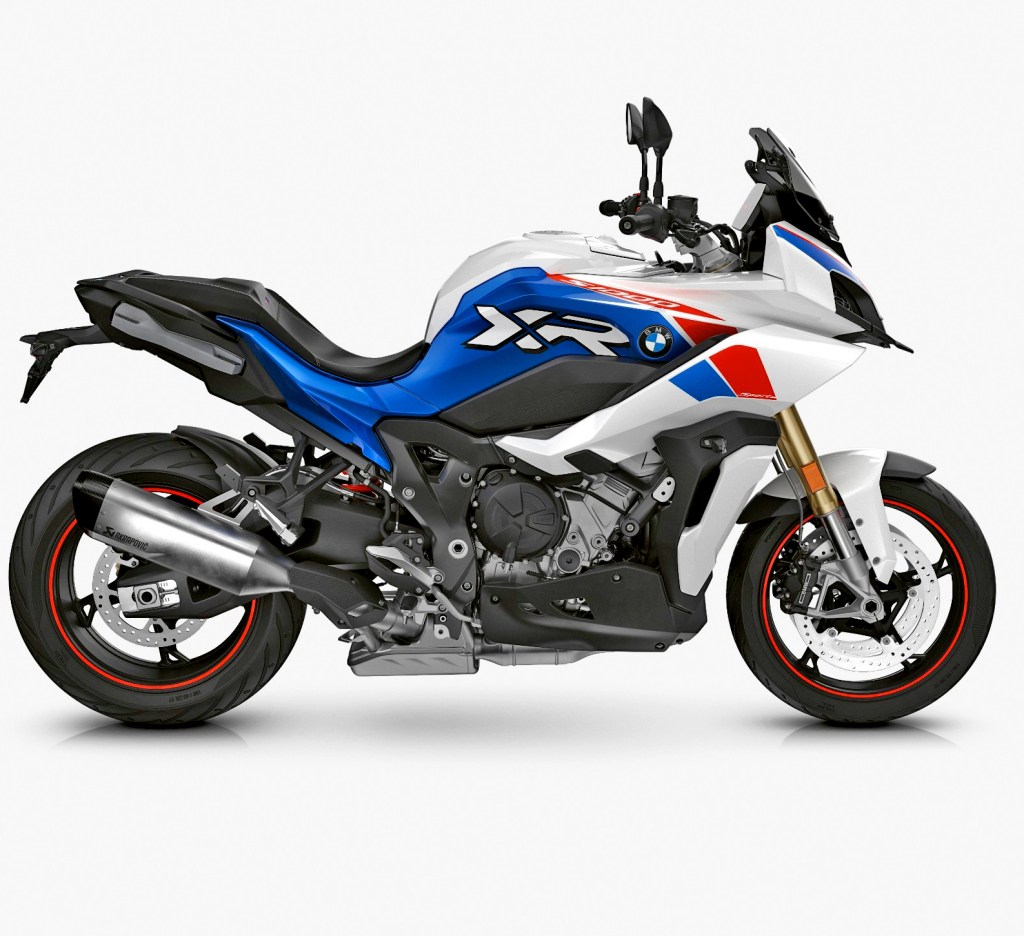
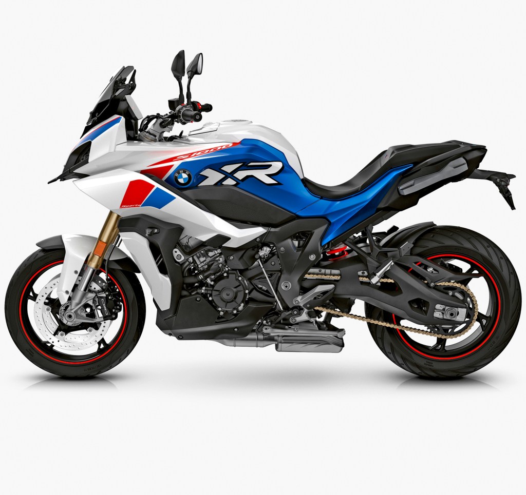
S1000XR is now available in “Style Sport” colour which is with Lightwhite non-metallic/ Racingblue metallic/ Racingred non-metallic. It looks like this:
There will be also some new and additional things: – Titanium sports silencer, M Endurance chain, Windshield Sport, additional Core Screen with Laptimer. – Tank cover and card pocket in motorcycle colour. – Tour package with expanded content. USB charging port, new luggage rack with integrated holder for 30 l and 49 l topcase. – New optional equipment: M milled parts package*. M folding brake lever, M folding clutch lever, M engine protector left, M rider footrests right/left and M pillion passenger footrests right/left.
This new colour with extended accessories should be ready to order from 1st of August! Check your nearest dealer!
Kopparö recreation area is located in Raasepori and you need to take a short ferry ride to enter the Sher Landet (Skärlandet) island.
Luontopolku = Naturepath
After you park your car and start walking the trail is very wide in the beginning. But soon you will see small bay on the right side and the trail is getting smaller. Here you will go across the suspension bridge.
Bridge is about 30 meters long
The structure of the bridge is quite scary. I will share a video in the end of this blog about it. Right after this bridge we started to hear bird screaming with very high note. It was like “Kvik – Kvik – Kvik!” But the volume of the shouting was extremely loud. And only few minutes after this we saw them flying in the sky -Two White-tailed eagles!
About 100m above our heads
This was a second time for me when I’m seeing this mighty bird. I guess these were two young ones because they were shouting all the time! (Mama! Mama! Look at me! I’m flying!!) Soon there was another bridge so we moved from Långön island to Stora Sandö island. This is like the “Main island” of the Nature path.
To Stora Sandö
The trail goes almost around the island and because it was quite warm we chose to turn to the left. I knew there would be a place for swimming!
Sandöedet
We didn’t have our swimming suits with us but it wasn’t a problem. We both did the the skin-dipping! The walk between Sandöedet and Stora Sandö grilling places is the most beautiful part of the trail! You can walk almost all the time very near to the sea and admire the clear water of the Gulf of Finland!
Stora Sandö island
We reached the grilling place of Stora Sandö and took another break there to eat our snack. I also made a Droneflight to take few pictures and the video of this beautiful area.
Grilling placeStora Sandö from east to North-WestStora Sandö Most eastern point
Stora Sandö
Amazing walk of Kopparö Nature Trail
After our snack my wife started to collect blueberries. Soon the half-a-liter bottle that we had was full of berries and we got to eat fresh blueberry pie at home! The whole trail is almost 8km walk and we did it all! In the map it looks like this:
Kopparö Nature Trail
In the beginning of this blog I said about the suspension bridge that I was little bit worried. So I made a video about it. It’s only in Finnish.
After packing our stuff and cleaning the cabin it was time to drive again. It was 50 km to Kuopio where we made about 2 hours stop. It was 1st time for my wife in this beautiful city. We parked the car to the new garage they have under the market square and came up to make a walk in the city center.
City Hall
Church and park
Snellman’s park
The Park
Churchdoor lock
Belltower
Market Hall
Kuopio
I have a BIG minus comment about the parking garage!! We went down to our floor (underground) from the side of this market hall and there was a sign that there will be this payment machine. But there wasn’t!! I had to walk to another elevator to find the damn thing! KUOPIO! Not like this! Our route went off from E4 highway in Juva but I had chosen quite small gravel road. Finally we entered the Pistohiekka & Lietvesi area. There is one special viewing point just beside the road.
Lietvesi viewing poin
From here it was only 80km’s to Imatra so in the afternoon we’re back in our house in Meltola. The summertour was over. The route for this day was like this:
We woke up little bit earlier than normally and had breakfast. Then we took a short drive to Korkeakoski (High rapids). 08.10am we were ready to start exploring…
Korkeakoski is the highest rapids in Finland
There was also a naturepath starting from the rapids but we didn’t read any reviews of the path. It was a bit disappointment since the path didn’t follow the river in the canyon. Anyway the thick Savonian forest was beautiful but there were totally too many mosquitos!!
Savonian forest near Korkeakoski
After getting back to the cabin we started packing our stuff… But while we were packing we suddenly decided to stay in this beautiful place one more night! So we didn’t pack our stuff but we headed to the canal that was also nearby.
Ahkionlahti Canal -or actually two canals
There’s actually 2 canals, the old one is built in 1866-74 and it was mainly used for log driving. But in the same time the population in Savonia was growing and people started to use boats to move around our country… The new canal was built in 1981-83.
Old one on the left
Old one goes “up”
The other end of the canal
Dronepictures of the canals
The total length of the canal is few hundred meters and the distance between two block gates is 240 meters. The difference of the surface in these two lakes is about 3,5 meters. I made also a short flight over the old canal…
Ahkionlahti Old Canal
Since we didn’t actually drive anywhere I’m not putting the route… Ahkionlahti Canal is located about 6,5km’s northwest from Maaninka.
And again we had quite a perfect morning for swimming! And for morning walk near the Marjaniemi lighthouse.
Marjaniemi beach and lighthouse, Hailuoto island
There is actually an active fishing village beside the lighthouse and a pilot-boat station so it was very interesting walk!
I made this video of the beach in Hailuoto
And on the other side of the island there is a weird art-installation called “Organum”. This is a 3 piece echo-chamber in the middle of the forest. The artist has made few similar all over the world! His name is Lukas Kühne.
OrganumWeird place
Then we started driving… First the idea was to stay on the western coastline but since the weather forecast didn’t promise too nice weather we kind of pointed rendom place on the map and it was Iisalmi. Then we started to find something interesting to see there and we found Korkeakoski. And that was actually located in Maaninka which belongs to Kuopio nowadays. It looked like a very nice place!
Short stop in Vieremä
But the drive became also a race against the rain! When we finally arrived to Maaninka it started raining right away. We chose to rent a cabin and we were quite happy that we found very nice one just beside the lake!
Our cabin for the next 2 nightsRight after we arrived it really started raining!
Waking up beside the river in Lapland is quite nice. I took my drone up even it was max 50m.
OunasjokiLevitunturi (mountain)Ounasjoki early morning
Later the weather was not very nice in Finland either. But there was a chance that it wouldn’t rain so we decided to go up to Aavasaksa -after we crossed the Arctic circle…
Aavasaksa is one of the first “Tourist attractions” in Lapland. There was visitors from other countries already in 18th century. In 1881 they built “Emperor’s Hut” for possible Russian Emperor visit but it never happened!
Emperor’s Hut
Aavasaksa is 242 meters high “mountain” just beside border of Sweden and Torniojoki -river. On the top of the hill is also one of the Struve Geodetic Arc -points. We took a walk around 2,5km path on the top of the hill. We had to take our raincoats because it was raining a little bit.
Aavasaksa
We also checked little bit of the city of Tornio -I was very interested how they had arranged the check in points on the border? But it was just a border patrol car beside the road before Sweden. There is an old church in Alatornio. This was built (1797) only 11 years before Sweden lost a war against Russia. And the church was built honoring the King of Sweden -I would say quite bad luck for him!
Alatornio Church
Then we drove all the way south of Oulu to the island of Hailuoto! Because weather forecast was quite nice for the evening and for next morning! Yes, the evening was nice but there was also quite strong wind!
DinnerPöllä beach, Hailuoto
Trying to make a dinner in this kind of wind was interesting. Ok the food was great but there was some sand and small stones as a spice! Route for the Day 11 was like this:
Escaping the rainy Norway… This was second day with rain and the weather forecast didn’t look nice at all… So we decided to drive back to Finland. In Norway we spent 2 nights in a car, 1 night in a camping area cabin and 2 nights in a hotel. Temperatures were mostly about 10-13 degrees celsius and it was cloudy.
Norway – Finland border in Kilpisjärvi
After 2 hours and 150 km’s we reached our homecountry Finland. It was still raining! But only about 50km’s later the rain had stopped and we saw blue sky!
Finland somewhere between Kilpisjärvi and Muonio
In Muonio we decided to buy new camping cooking system (Trangia). And it was a good decision! From Muonio we took Levi as our goal! And there we drove straight to the top… Or not quite, you still have to climb about 100 meters higher from the parking area. The top of Levi is 530 meters. There is nice wooden path to walk around in the top of this “mountain”. It’s only 700 meters but the views are quite amazing to all directions. We had even a rainbow in the beginning of our walk!
Wooden path around the top of Levi
Then it was time to find a place for sleeping in a car. There was nice lean-to just beside Ounasjoki -river. A perfect place to get to know better all of those mosquitos…
Ounasjoki goes down to Rovaniemi and connects with KemijokiLean-To in Finnish it’s LaavuCamp-fire makes a special atmosphere in the evening!
After sleeping in a car quite many nights and 2 nights in a camping area cabin and 1 in a room with kitchen it was time to take a hotel room. We drove to Tromsø and took 2 days in the hotel (Smarthoel Tromsø was very cheap!) The way to Tromsø was with one ferry -from Svensby to Breivikeidet. This was about 13€. After we put all our stuff to the hotel room we went to check Arctic-Alpine Botanic Garden. This was very nice visit! So many beautiful flowers and plants!!
Amazing colourful flowers
The area of this Arctic-Alpine is not too big but we checked all the flowers quite closely! After the garden it was to time to go UP! The cable car of Tromsø is called Fjellheisen and it will take you to 420 meters above sea level!
Fjellheisen
The weather was little bit better than it was in morning so we could actually see something from up there! And took some nice pictures! In the evening we were eating pizza just beside our hotel. The restaurant was called Casa Inferno and with the price little bit over 20€ we ate very nice pizzas!
Local traditional food
The route for this day was like this:
Day 9
Like I said we didn’t move anywhere from Tromsø. But this second day it was already raining. So we visited the Polaria. We saw quite many fishes and plants and also the feeding “show” of the seals. They had 2 small seals (Harbour Seal) and 2 big ones (Bearded Seal). The show was quite nice and these guys knew few tricks. Everytime they did some nice trick the stuff gave them the reward. But I was thinking why they had to be there in this small pool??? Why they will not them to go free?
Sea anemoneSmall moray
The most interesting “show” was the short movie about Svalbard. That would really be interesting place to visit! The movie was mostly about how the landscape has been changing there. All the glaciers are soon gone… In the evening we had a dinner in Asian place called Tang’s restaurant. About this We would give even bigger recommendations because the price was almost “normal”. This day there was almost no driving at all.
Day 7 was about driving west in quite cloudy and grey weather. It was a big pitty because there is many places to admire the landscape and the view to the sea.
Few pictures from the E6 to the Arctic Sea
We took also 1 ferry from Olderdalen to Lyngen. It was about 17€ and took about 50 minutes. But soon after this ferry we arrived to our destination! Blåvatnet This is a small lake located in Lyngen municipality in northern Norway. Area is also famous about Lyngen Alps where the shape of the mountains is more steep than ordinary fjells or mountains in Norway. The highest peak is Jiekkevarre with 1833 meters. Blåvatnet is one of the most famous hiking places in northern Norway. The lake is about 200 meters higher than the parking area and it’s about 4km’s walk. The landscape is rugged with lots of stones and small rivers to cross. Luckily for us it looked like it would not start raining. We started the walk up to the lake about 3.40 pm.
River after river
Wooden paths
Amazing views
And river
And river
This rock was about in the halfway
Clouds over the mountains
Rugged land
And river
Getting closer
The walls of Mordor!
Almost 2 hours hike to the lake
I was little bit afraid when the weather is so grey that we will not see the amazing crystal clear blue colour of the lake. But there was no reason! The water of the lake comes straight from the glaciers in the mountains and it stays very very crystal clear all the time!
Blåvatnet
The last 200 meters hike to the lake is quite difficult! The stones are big and sharp and there’s many chances to step wrong and twist your ankle or even worse. The consentration and physical struggle made me sweat quite a lot. Now I understood why quite many said to take your swimming pants so you can swim in the lake! I didn’t have them with me (So stupid!) so I just took off my jacket and t-shirt and flushed my upper body in the lake! On the way back I took only 3 pictures -Here’s one of them:
6.30 pm in Northern Norway
When you search the pictures of Blåvatnet you will ofcourse find those ones first that was taken in sunny weather and with clear blue sky. But when you come here you can’t choose your conditions and weather. We are very happy that we saw the lake at least without rain! The route for the Day 7 was like this:
It was beautiful morning beside Barents/ Arctic Sea. We started driving first to south towards Lakselv city and then to north towards Nordkapp. Even it was quite nice weather I knew it wouldn’t be like this in the North Cape -ofcourse I was hoping that there would be sunshine! We made the test cooking with our camping cooking system and I even called to Minna Jakosuo. I knew she would know the answer and she did!!
Cooking water as a test
If you keep “The Heart” of this cooking system in the same package with all the pots, the steam from the burning fuel will catch the pots! And it is almost impossible to wash the taste away. Even this Alcohol Stove has a lid with seal the steam of alcohol is still going outside the heart!
Alcohol stove
So we didn’t have a proper cooking system anymore… All the pots were ruined by the taste of burning alcohol. Luckily we had quite a lot of food with us that you can eat if it is cold so we didn’t care too much about this. After very nice road from Lakselv to Honningsvåg (about 160km) we at least could check a little bit of this village and the views from the “Viewing point” from the military above this village.
Honningsvåg harbourSame village from above
So we didn’t visit the North Cape. It was my second time on this island and again I didn’t go to Nordkapp… (Shame on ME!) We had to drive the same beautiful road back to the mainland. The more south we were driving the more beautiful the weather was coming! On the southside of Skaidi we made a stop beside the road. It was amazing place with very nice landscape. I made even a drone flight.
Question Mark
Goahtemuorjohka
Picture taken by my wife
Click any of the pictures to see it bigger
We took a cabin from the camping area in Lakselv for the night so we could make proper food! The route for the day 6 was like this: