This was the day when we finally entered the Alps and the route that I planned this whole trip (Route des Grandes Alpes). But before we actually got to ride the endless hairpin corners… we visited the Les Gorges du Pont du Diable.

This is a place where the river has been “digging” the limestone for millions of years. It’s not a cave but almost… The hole is 40 meters deep. It costs 6,10€ to take a 40 minutes tour with a guide and it really is worth every penny!!

It is amazing place! And it’s only 20 minutes from Thonon Les Bains.
Then the first climb we took was Col de la Colombiere which is 1614 meters high mountain pass near Cluses. Then we climbed Col des Aravis, it’s still not very high but it offers one of the best views to Mt. Blanc!

You can see the highest mountain in Europe from many places if you’re driving south of Col des Aravis.
Then we had Cormet de Roselend, which is almost 2000 meters (1968 meters), this offered already very spectacular views from the top!! Especially the Lake Roselend with the clear turquoise water is really worth to make a break and admire the view!


And finally we had the highest mountain pass in Europe in the afternoon: Col d’Iseran (2764 meters). The summit is still a lonely place! There’s no restaurant or no souvenir-shop just an old chapel made of stone… and I think they don’t even use that anymore!

There’s still old meters in the sign… It has been checked few years ago that the real hight is few meters lower!

When we rode down to Val d’Isere it started to get cloudy. We had one more climb to make since we had our accommodation in Italy (Moncenisio). We did see a little bit of of the Lake Mt Cenis, but after we crossed the border we had no visibility anymore! We’re riding in the clouds! And the road to the amazing Chalet Sul Lago was extremely narrow with the branches of the trees coming very low… it felt like a scene from a horror movie!! And finally when we found the place… it had a very pleasant surprise for us!

No, it is not a Michelin restaurant with any stars… But it is mentioned in the Michelin quite many times (as you can see!) -And yes the food was good!
Here is the route for the day 9.
Tag: tourinki
-
-
After breakfast it was time to start riding again. My Tomtom Rider 410 showed us the way to the nearest gas station in Weil am Rhein… but what I didn’t remember in that point that in highway in Switzerland you’ll need the Vignette! And the nearest Shell was AFTER the border checkpoint in autobahn/ highway with only possible direction to Switzerland… Oops! (We decided that we are not going to buy the expensive Vignette -we would rather ride the small roads in Switzerland area).
After a short discussion with customs officer we were able to make nice move to the other side of the customs area and ride back to Germany… and soon after that ride through the city of Basel. That took about 1 hour! In the southside of Basel we actually got our first real mountain hairpin corners when we climbed to Passwang Pass (elevation 1204 meters). And we had the first break in the “summit cafeteria” (http://www.alpenblick-passwang.ch/).

The view to valley was amazing.
Then we had Grenchenberg! What an amazing ride it was! The road is so narrow (climb from the north) that it is simply impossible to overtake a car. And I was so kind that I stopped and wait for the other 2 riders… and we had to drive behind a car for a long time.
Just before the summit there was a place with lots of cars, tents and people… I don’t know if there was a some kind of special meeting or a camp(?) but it looked very strange! (In video 09:00). We had a nice break in the summit restaurant.
The southside road of Grenchenberg is not that narrow, there are even some busses driving… Then we entered Bern.
I was actually quite scared about riding through Bern! But it was Sunday early afternoon and there was not that much traffic. We did see the city center terminal of Bern and it was quite easy to ride through. From Bern we choose the road beside (and under) the highway to west as we headed to Lake Geneva. In the way we got some pretty nice views to the Lake of Gruyère (a reservoir).
Also the view to the Lake Geneva was amazing! I had planned the route to the beach Boulevard of Vevey, Clarens and Montreux… And that was a big mistake! There was annual Jazz Festival of Montreux going on… it took about 2 hours to ride that boulevard! (But we learned to do some nice splitting!) We did see the tents! And we heard some music! So I guess we can say that we were at the festival!

Finally after a long day we arrived in Thonon-Les-baines. It’s a city in French side of the Lake Geneva.

The route for this day was like this. -
We got 1 more rider to make this tour with us! He’s Timo and he rides Honda VFR 800, and it’s red too!

This days route was called “Lets get the real good look at River Mosel!” -And yes we did!
The route was like this! And we’re following the River Mosel all the way from Koblenz to Trier and then to Luxemburg… It was more than 230 km’s of River Mosel and those grapevine or wine bushes on the both sides of the river! I think that’s enough… Luckily we did ride something else too! In the last part of the route we had nice ride in Eppenbrunn!
And then finally the GPS found a route that it is even hard to find from the map!!!
This must be the MAIN ROAD from Germany to France!
We had accommodation in Obersteinbach, France. It was nice and “bohemian” just in the right way! -
This was from Edersee to Bendorf (near Koblenz) like this. There was a risk of rain so we didn’t ride the whole tour Lake – Edersee. That area is very much recommended with nice roads all around!

In the half-way of this day we noticed that the Ducati’s chains are very loose! Luckily we found a car and motorcycle garage where they tightened the chains right away!
 As we got closer to Koblenz there was a very nice road with multiple tight corners!

I let the Ducati ride first. -
Made few mistakes! Planned a long route with 2 times crossing the Russian border… Ooops! But I’ll tell you later about it.
First there was a ride from Plinkses to Klaipeda harbour, and from there we took a ferry to Curonian Spit. Ferry costs 3,35€. And after we arrived the spit there was a roadtoll (5€/ bike). And we also had to pay the toll again in Russian side (that was a little bit more than 4€). The road in Curonian Spit is beautiful, it even has some corners and uphills-downhills.
We stopped in one beach to take some pictures of the Baltic ocean. We also stopped in Nida to buy something from the shop.

After Nida it was time for the first border check-Ins! These first check-Ins took about 1h 30mins! Then we’re in Russia!!

This is Amber museum in the center of Kaliningrad.

And this is the worlds biggest castle in Malbork Poland.
But before we could ride in Poland we had to cross the border again! The Russian side of the border was ok, (quite fast) but then the Poland side of the border-check was with a very long line!!! We had to wait more than 2 hours!!! What a catastrophe! We were so late in our accommodation! It was 9,30 pm and we started 8.30 am and there in the middle we moved from timezone to another…. so it was more than 14 hours of ride!!!Note to myself:
– If you’re about to ride Curonian Spit, you better have 1 whole day to do it!
– If you’re about to cross the Russian border twice a day, don’t ever think it’d take 2-3 hours! It will take more! -
The route was Kirkkonummi – Espoo – Helsinki – Tallinna – Pärnu – Riika – Saldus – Plinkses and about 500 kilometers like this! It was mostly big road and very boring day, the only merrier road was the Old Pärnu Road on the southside of Pärnu. There we also stopped ro take a swim in the Bay of Riga. The water was very warm!

Here is the parking area about 100m away from the sea. The day was HOT (about +30-32 celsius) so swimming was a very good idea!

This is a view from the resting area just outside Saldus -city. It was a Beautiful place.

Here is a picture of our MOST BEAUTIFUL hotel! -
FInally I had a chance to take a weekend tour!! I started on Friday 27th of May and I choose the route and the direction where I had motocaching spots as many as possible to find!
This was my route on Friday. The first motocache I marked as “found it” was from Urjala to Huittinen, it’s a panoramic route in a typical Finnish countryside landscape.

This is called “Road of the Magic Night”
Later I stopped in a cafeteria with a beautiful location beside the lake and a bridge.

Sadly this Otamus Cafe wasn’t open so it was no snacks for me! Quite soon after this cafeteria it was one of the twisty roads that I had been waiting! But (WTF!?) it started raining! I had to put on my rainsuit to avoid getting wet and I didn’t really enjoy the corners… Ok, few kilometers in tho north part the road was dry again.

Friday I added 7 new caches to my list. Last one was the cafe beside the militarybase Niinisalo, It’s called a Sotilaskoti in Finnish and I think the English word is naafi(?)
These cafes are usually quite cheap comparing to ordinary ones.

The route for the second day (Saturday 28th) was like this. Again I was choosing roads and spots I could mark as found in motocaching.net. The first one was very old road from the middle ages called “Kyrönkankaantie” (Cache only in finnish). The first time it is mentioned was in 1556, but today it is only rarely used road in the middle of the forest. It would be great ride for a endurobike!!
At 02:00 I choose the wrong road and at 02:30 I stop to wonder why the GPS shows that I’m somewhere in the middle of nowhere??!! And I make the U-turn!
The second spot was a tower in the top of the mountain in the national park (Lauhanvuori national park). I have a physical fear of heights (not mental), if I go to a high place I haven’t been before I start to feel it on my stomach and in my feet. When I was younger I’ve even passed out few times. In this tower I had some trouble to stay on my feet but after a couple of minutes it was ok. I think the tower is over 20m high!

There was one road in the national park that I took. This was fun!! (And pitty I didn’t have my KTM!)
In the routemap it shows that I’m making U-turn at the end of this road, but since there are no traffic signs I just ride through to the bigger road (at 11:00 in the video)
Little bit later I took another tower, this was not as high and it was new. But when I climbed to the top I could feel the tower moving!! That didn’t feel ok at all!! They built it too light!

Then there was few rural roads, one of them had so big stones in it and I really didn’t like it at all!! (With my KTM Enduro it would’ve been ok!). Then I arrived in Karijoki, there’s a very old cave called “susiluola” (Wolf cave), it is the only place in northern Europe
where they’ve found some evidence of humans living before the ice-age! Although the evidence is not certified to be as old as they say (120 000 years old)! Here’s some info in english.

It was a disappointment that you coudn’t visit inside the cave!
Just few kilometers from the cave there’s a skiing center where you can ride your bike to the top of the mountain -and there’s a great view!

Not far away from here is the city called Kristiinankaupunki, I’ve actually never been here before and there’s one strange alley… It’s very narrow and it is still a 2-way street! This is the most narrow 2-way street in Finland!

The name of the road is “Kissanpiiskaajankuja” (Catwhippersalley… Yes, a guy who’s whipping the cat!!)
From Kristiinankaupunki I was riding straight south following the coastline. The road to Siipyy, Merikarvia and Ahlainen is not extremely good… but it’s not boring either.

This is the belltower in Siipyy.
Late afternoon I was finally arriving Tahkoluoto and Reposaari. These are outer islands but possible to reach by road. I was lucky to have a beautiful sunny weather while riding the road to these islands. I found the beautiful restaurant on the south-end of Reposaari called “Merimesta”. I choose to eat the buffet even it was not cheap (27€) but it was all worth it!!
Finally spent the night in Pori and woke up next morning in cloudy west-coast city.
Sunday (Third day) route was like this, still choose the roads following the coastline. Visited the harbour in Luvia, I had never actually been there before. Usually there’s a new sailboat in the pier called “Ihana” (Wonderful) and I was so early in the morning it was not out in the sea and I was able to see it!

I rode to Vuojärvi Mansion -that is a very big and beautiful old mansion in the westcoast!

Stopped in Rauma to check the old town and it still is so beautiful and amazing area!

Then slowly I arrived to Turku and I checked few places before I chose the highway to Helsinki and the way home. It was pitty that Sunday was cloudy… I even had some drops of water in the morning but I didn’t get wet.
Here’s one picture from Turku… One of the most famous buildings in Finland:
Turku Castle!

This last day I had the longest route but it was the shortest day… And it’s because I choose the highway Turku-Helsinki, almost 170 kilometers of 120km/h speed. I was home at 4pm.
Now I’m waiting my next trip which is starting on 26th of June. That will be 3 weeks in Europe and maybe more than 7000 kilometers!!! -
Finally I desided to take my FIRST bike out! And what a weekend it was! Almost 700 kilometers (>500km on sunday) with my first bike BMW S1000XR!
 It’s not difficult to guess what was my first first direction? Yes, to Inkoo and Fagervik! That road simply makes you smile everytime you ride it!

The Café wasn’t open but I didn’t mind. I only stopped to take this photo and then I continued to enjoy my first “real” motorcycle ride (of 2016)!
On sunday we had a groupride in eastern Uusimaa. There was 11 bikes in the start.

This picture is from the first break in Pukkila.

And this is from the last break in Kulloo. The route was just fantastic!! You can hardly find any better roads this close to Helsinki (East side). Only in the north side of Pukkila we visited shortly Päijät-Häme province, otherwise we stayed in Uusimaa province. Here is the route. -
Would it be something like this?
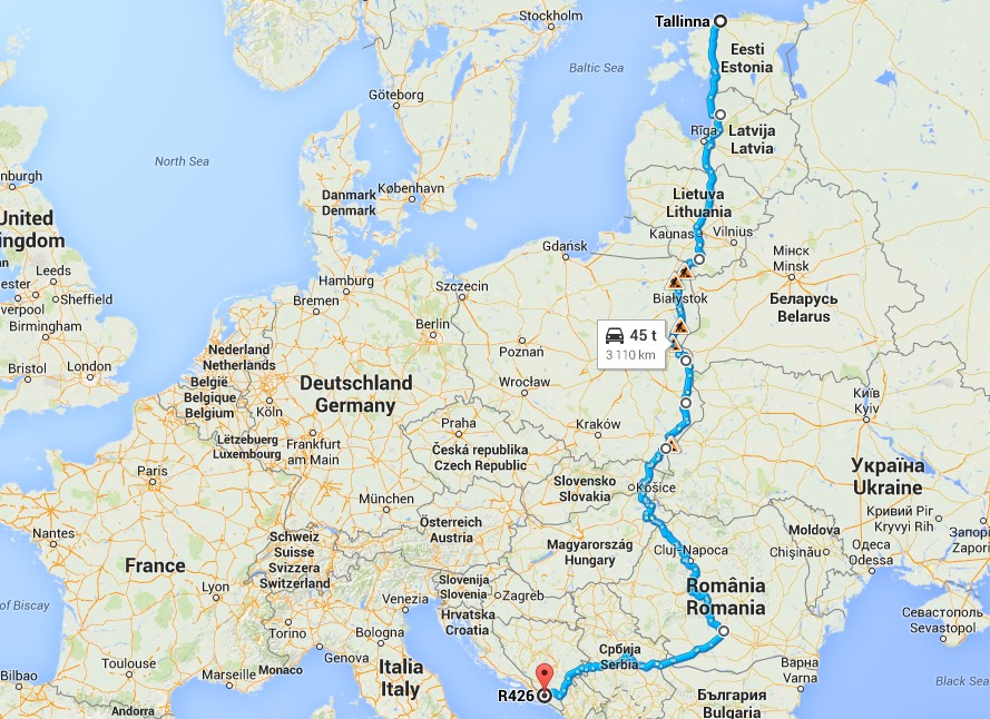
Helsinki – Tallinn by boat, then ride to Sigulda Latvia. Then Lithuania, Poland, Slovakia, Hungary, Romania, maybe Bulgaria, Serbia and Bosnia. Then by Adrian Sea to Croatia, Slovenia and finally to Italia and Milan. From there the bikes would go by truck back to Finland and the riders takes the flight back to Helsinki.
This is the plan now, lets see how much it changes until the summer 2015 is here.

-
Sunnitteilla tulevaksi kaudeksi:
– Letka-ajelu-kausi alkaa huhtikuussa
– Lähtöjä entistä kauempaa pk-seutua (Lohja, Rixu, Lahti, Porvoo, ???)
– Pidempiä reittejä
– Pääsiäinen myöhään huhtikuussa, siihen joku parin-kolmen yön reissu?
– HMKP Kouvolassa la 17.5.2014
– Juhannuksen jälkeen AlppiTouRinki johon lähdössä 12-14 motoristia, parin viikon huikea reissu
– Elokuussa ilmeisesti 16. päivä on ORG -kesäpäivä, mahdollisesti 2 päiväinen reissu tähän
– Itse veturilla tavoitteena vetää vain joka toinen sunnuntai… Muita vetureita: nysse, Suzu-ukko, ???Tämmöisiä suunnitelmia kesäksi 2014…